
Ionian Basin redux via Lake Sabrina – July 23-27, 2025
A return to one of my favorite places in the Sierra. Last winter in the throes of trip planning, I managed to convince my friend Paulina to join me for a 5-day loop hike through Ionian Basin. We planned to enter via Echo Col and exit via Haeckel Col, starting and ending at Lake Sabrina to avoid any need for hitchhiking or car shuttling.
Day 1: Lake Sabrina to Echo Col
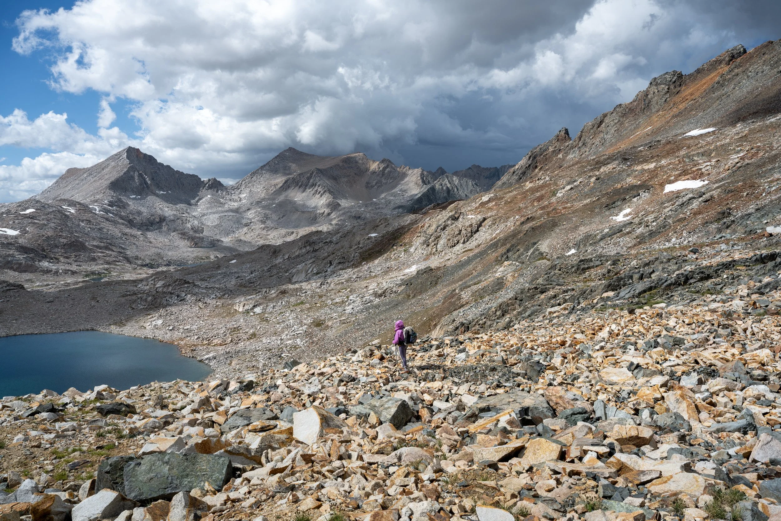
We set off bright and early from the Lake Sabrina trailhead. It was still quite cold at 6:30 AM and would remain so for most of this trip. While the lakeside traverse and switchbacks up to Blue Lake take a bit of time, worsened by the too-heavy loads we were carrying, most of the early hours of this day passed by in a blur. We took a nice long break at Blue Lake and another once we reached Moonlight Lake.
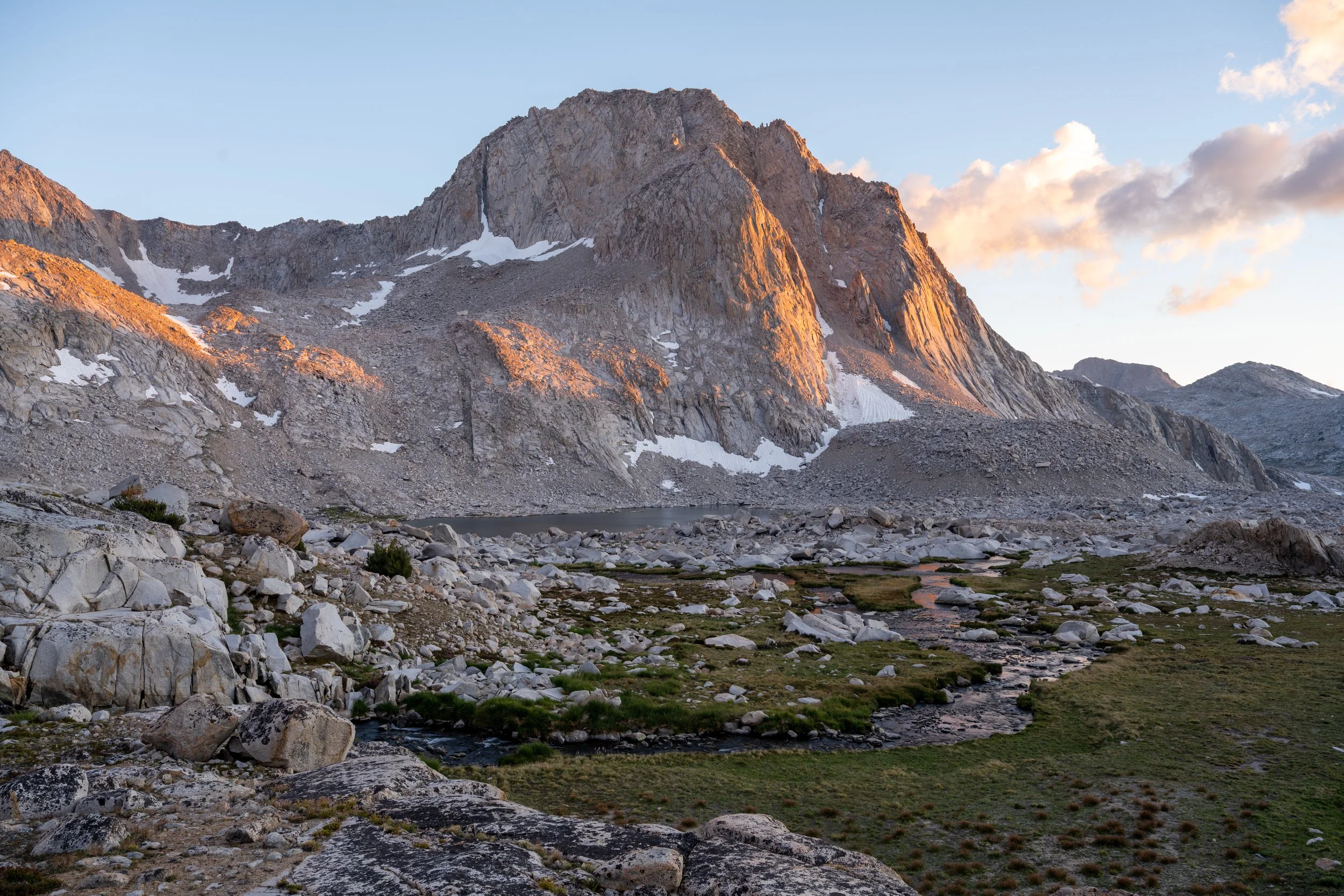
Moonlight Lake reminds me a bit of Jade Lake in the Cascades, its waters fueled by the remnants of glacial ice further up the drainage. It’s curious that Echo Lake, which is further up than its lower neighbor and should by virtue of its location directly beneath perennial snow and icefields (however small they may be nowadays) have the same color, is more of a deep, dark blue. At Echo Lake, we took a break to add more layers. At this point, the forecasted storm clouds were hanging over the Sierra crest and we could feel rain drops periodically. We debated for quite a while over what to do. Plan A was to try making it over Echo Col as we had originally planned. The danger here was a difficult retreat if thunderstorms were to strike. Plan B was to start the traverse over to Echo Col and set up camp on one of the numerous bivy sites I knew existed from my trip last year.
In the end, we didn’t reach a consensus and just decided to set off and see what happened. By the time we crossed a cairned creek and the last of the suitable campsites, the sun had started to reemerge. We begrudgingly crossed the remaining snowfields and took a break below the final push to the top. This day is probably the worst I’ve felt in the backcountry in a while. Despite how many years I’ve been doing this, I never seem to eat enough calories on big days like these. I was exhausted and nauseous, only buoyed by the fact that we didn’t have much further to go.


The line we chose up to the col was, to put it briefly, not a good one. It consisted of steep, loose talus and scree, and we set off a couple of rockfalls in the awkward maneuvering to more solid ground. On my first visit here, I ascended further to climber’s right where the rock was very solid; I’d recommend doing that to anyone reading this. Eventually, we made it to the more solid rock beneath the col and made short work of the final moves, where we were greeted on the south side by the largest concentration of Sky Pilots I’ve ever seen in the Sierra.
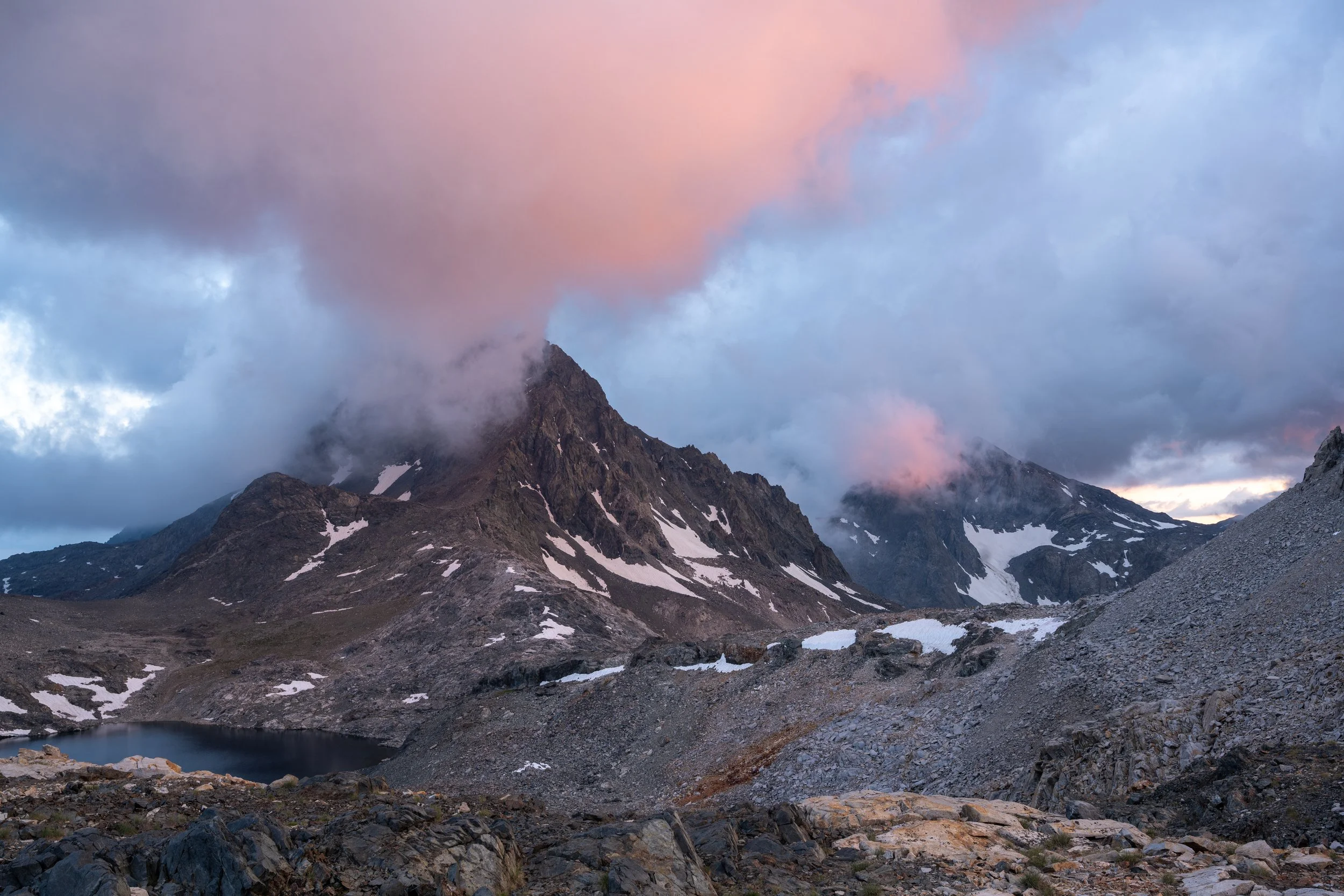
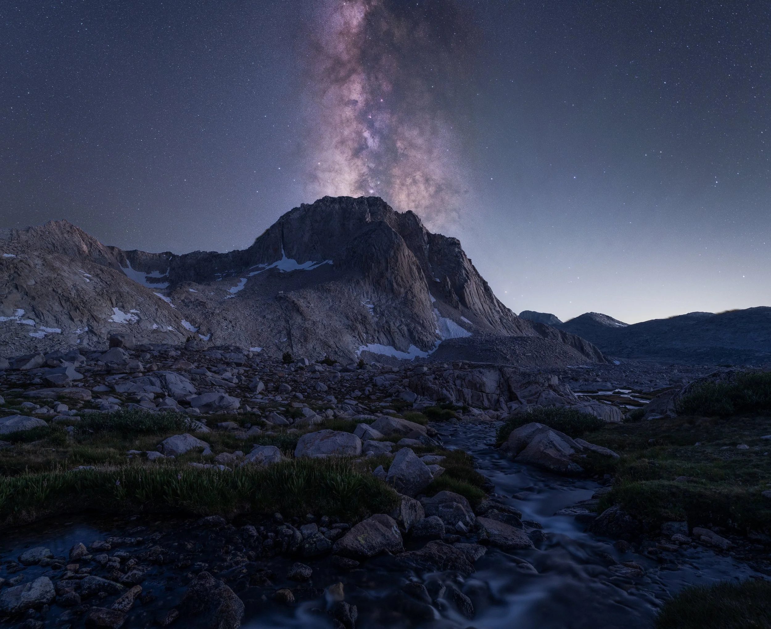
We descended about 300 ft to a flat patch of dirt and grass with nearby snow for melting. The only good part about this descent was the gorgeous backdrop of peaks with purple clouds; my battery was otherwise completely spent at this point. We slowly setup camp and ate dinner in a mostly pleasant silence. Because I seem to be a glutton for sleep deprivation, I decided to try taking some Milky Way shots which occupied me for another couple of hours.
Day 2: Echo Col to Black Giant Pass
We slept in pretty late the next day and waited until the sun hit our tent before starting to pack up. The late start wasn’t an issue since we’d only planned to go as far as Black Giant (or Black Divide if we were in good spirits and the weather cooperated). I was personally in much better spirits with a solid night of rest and knowing that the terrain would be comparatively easier today.
The descent down to the JMT was relatively slow-going due to steep talus and the necessity to navigate around cliffbands below Lake 11428. We only stayed on the JMT for a couple of miles before peeling off towards Black Giant Pass, but it was a glorious couple of miles without having to watch one’s footing or worry about impact damage to knees and ankles.


Just beneath Black Giant Pass, we again came to an impasse as the storm clouds overhead seemed to reach their climax. Paulina was convinced we should push on and over Ionian Pass to get to Black Divide. My concern was that the densest storm clouds appeared to be concentrated right over that particular basin; if that ended up being the case, we would likely have to axe our planned sunset summit of Black Divide Peak, making a foray into that basin pointless. We decided to just camp at Black Giant Pass and potentially summit Black Giant that evening if the weather cleared or otherwise defer the sidequest until the next morning.
The weather cleared enough to have a stellar moody sunset, but we didn’t end up summiting Black Giant due to concerns that the payoff would not be worth it. After all, low clouds still hugged the peaks, a relative rarity here in the High Sierra. We turned in for the night and I set an alarm to try and shoot some Milky Way photos if the clouds ever cleared up.
Day 3: Black Giant Pass to Swan Lake (with side trip up Black Giant)
The next morning, we woke up to photograph sunrise and then promptly went right back to sleep. Paulina was too tired to join me in my quest to summit Black Giant but I was determined to succeed after not having enough energy to do the side trip last summer. I set off around 9 AM and made excellent time with a light day pack. The west slope of Black Giant was blanketed in Alpine Gold (Hulsea algida) and Sky Pilots which slowed my pace dramatically. I’m confident I could have made it to the summit in 45 minutes without the numerous photo breaks, but I took my time with my photography since I knew we were only moving camp about three miles.

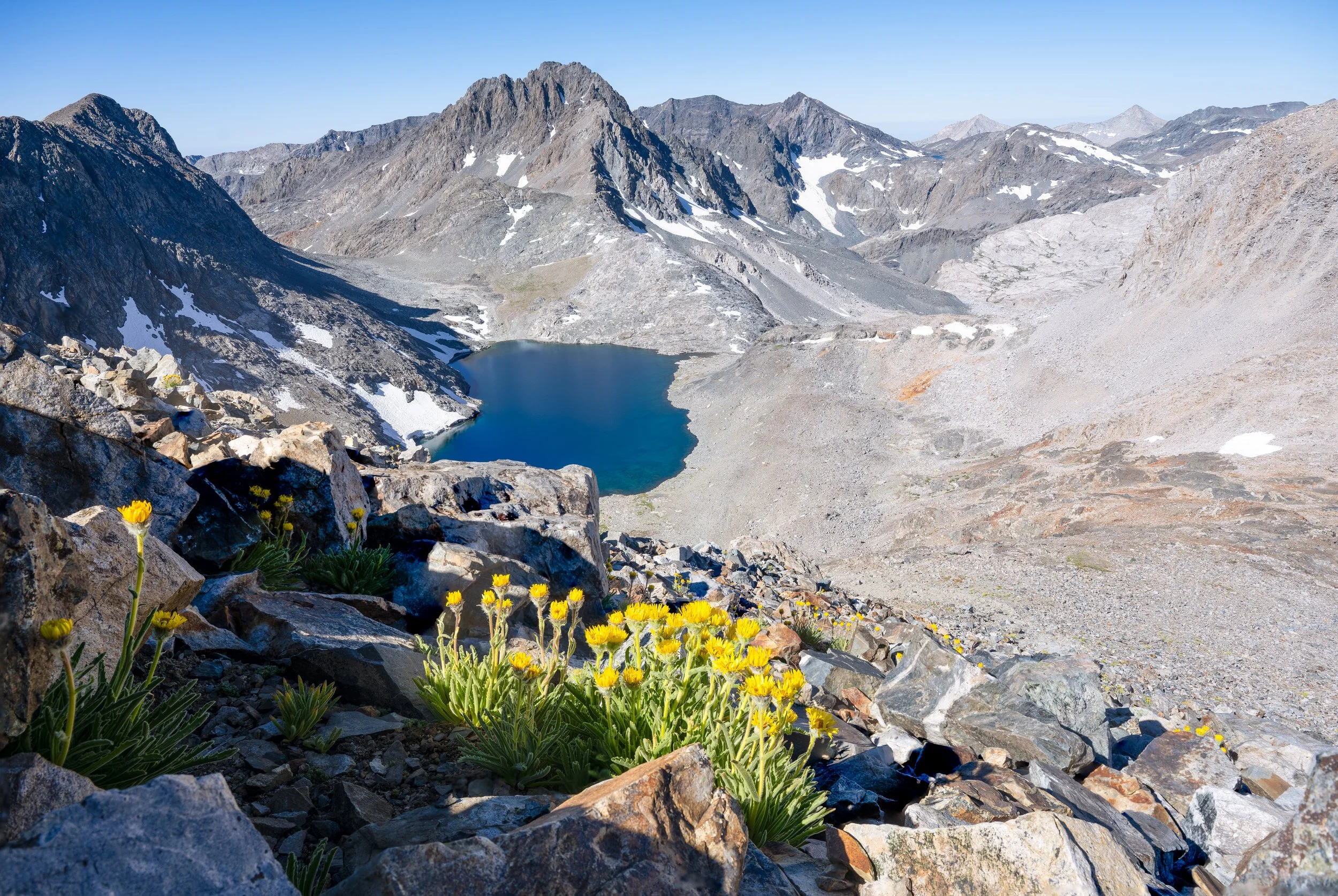


The upper reaches of the mountain contained a couple of false summits which felt like they would never end. Eventually, though, the views opened up dramatically and I had a clear line of sight down LeConte Canyon all the way to the Palisades. I stayed on the summit for nearly an hour before heading back to camp. On the way down, I was surprised to meet a group of three who were doing a day trip from their camp near Wanda Lake. Unfortunately, I might have rattled them by plunge-stepping and accidentally knocking a rock loose. While it wasn’t in their fall line and stopped after maybe 20-30 ft of rolling, but some of their party had already seemed to not be thrilled with the loose rocks and I’m sure the rockfall only added to their apprehension. We chatted a bit about itineraries – they were doing a lollipop from Lamarck Col, though I didn’t quite catch their intended return route – before they disappeared over a ridgeline and I was back at camp.


We slowly packed up and made the descent all the way to Chasm Lake. Here, storm clouds greeted us like an old friend. It was cold and windy with some intermittent drops of rain, but just like all the other days so far we managed to avoid any thunderstorms or serious rainfall. The next couple of hours might be the slowest I’ve backpacked in a long while. The altitude in combination with cliffs along Lake 11837 made for very slow going and the constantly drifting of the clouds made it difficult to stay comfortable without constantly removing and adding layers.
Cross country travel in the shadow of Charybdis.
Finally, we were at Swan Lake and setting up camp on the only flat patch of grass we could find. I wasn’t feel great due to undereating again, so Paulina did most of the tent set up while I wandered over to some snowmelt to filter water for us. We ate a quick dinner and then waited for what we hoped would be a great sunset. Unfortunately, the weather had other plans and low-lying clouds drifted in and out of the lake basin we were in all evening.
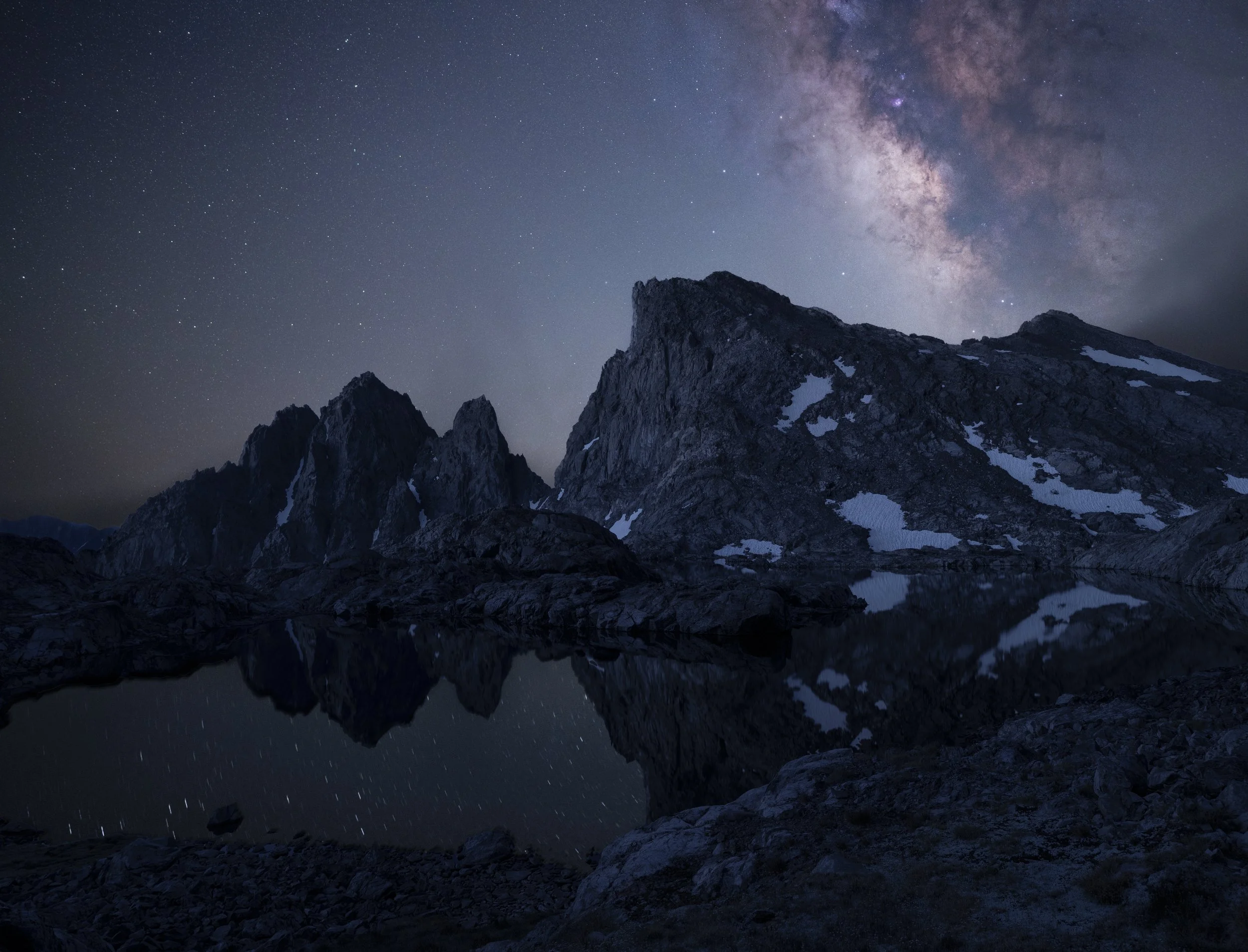
Parting clouds revealed the Milky Way and stars over Scylla and the Three Sirens.
Day 4: Wanda Pass to Mt. Huxley tarns
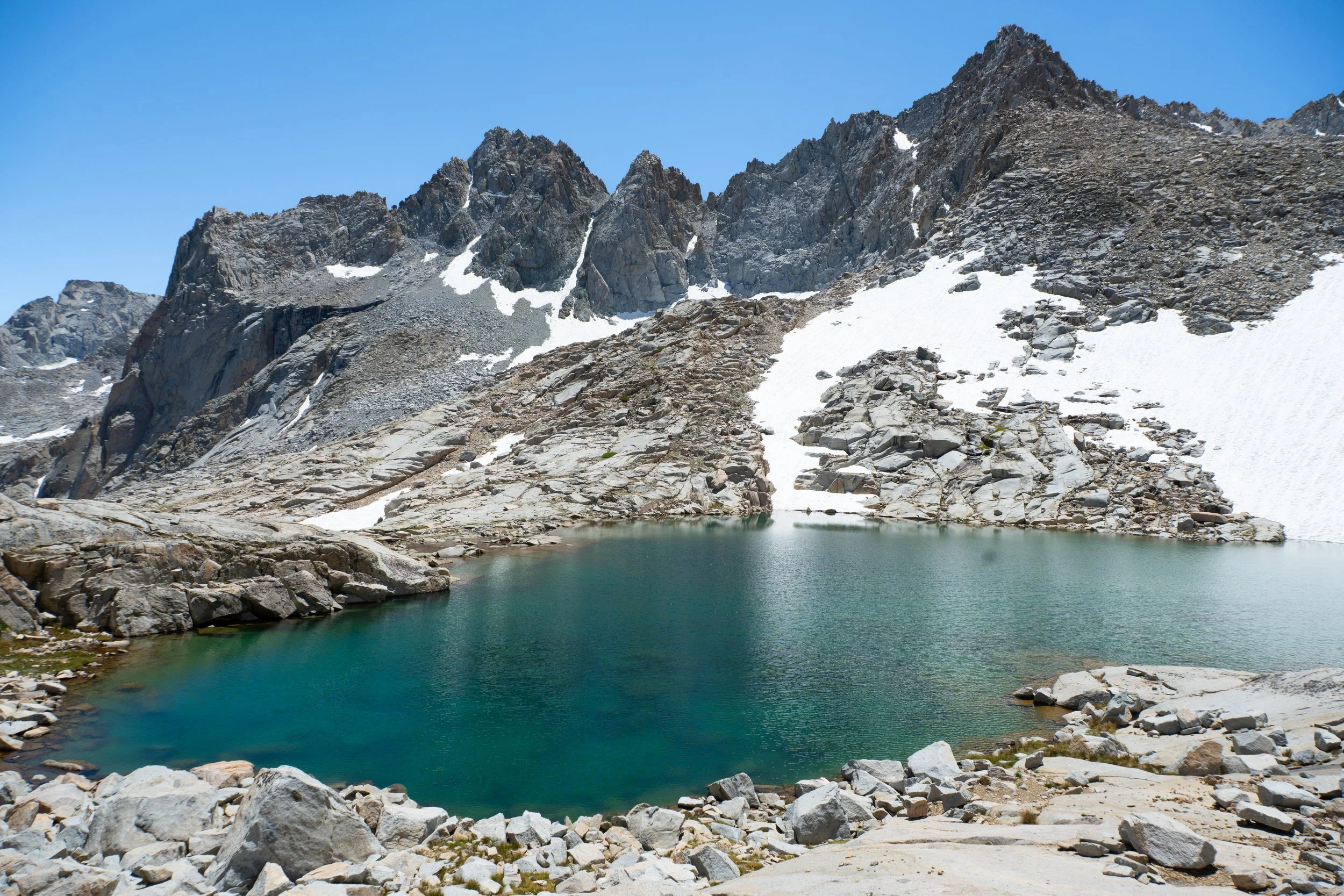
I wasn’t sure how long this day would take us. I remember it taking me a while to get back to the JMT from this lake last year, but we’d only be traveling a couple of miles on it before essentially arriving at camp above Sapphire Lake. We left camp around 9:30 AM and didn’t reach the top of Wanda Pass until nearly 1 PM (although part of this was due to my needing to take an emergency bathroom break on the ascent which ate up a good half hour!). We traversed from Lake 11837 directly to Wanda Pass, which consisted of large, tedious talus near the top of the pass and much up and down due to numerous gullies cutting across the slope. I would recommend descending to Lake 11592 and then ascending the much more pleasant-looking southeast slope instead.
The descent to Wanda Lake felt endless. It was over 1000 ft of talus hopping that caused a flare up with my knees, and rather than finding salvation once at the grassy shores of Wanda Lake, we were instead greeted by biblical hordes of gnats. I breathed in gnats by the dozen, probably in both my mouth and nose at the same time. There were bug guts all over my pants. I ran across the talus while desperately swatting the air. It didn’t matter that these were gnats and not mosquitoes, incapable of biting let alone through my thick hiking pants. Once I was uphill of the lake shore, I took a break and waited for Paulina. She emerged on the horizon donning her headnet, something I probably should have done. We cursed out loud and said some very nasty things about Wanda Muir, for whom the lake is named. When we got to the JMT, some thru hikers remarked on how bad the gnats were on the trailed side of the lake as well.
The time on the trail passed quickly and we found ourselves at Sapphire Lake in no time. We directly descended a somewhat steep slope to access the wide inlet of the lake. The views here were excellent with the jagged spires of the Evolution Range serving as a backdrop and the lush green meadows uncharacteristic of the Sierra painting the foreground.


I needed a longer snack break so Paulina went ahead and started up towards the Mt. Huxley tarns where we’d be camping for the night. This ascent was confusing in that there were many different plausible directions to ascend – direction on talus to the south, talus and brushy slopes further north, and broad grassy benches even further north. I didn’t see which way Paulina went so I started up talus that gradually became brushier, eventually cutting over to the benches where the going was very easy. When I got to the top, I realized the area was not flat as my topo map had made it seem and it was going to be very difficult to find Paulina if she was already up here. She must have had the same thought because we both fired off inReach messages to each other at the same time. Thanks, Garmin!
The Milky Way over Mt. Huxley.
After reuniting, we pushed further in towards the highest small tarn in the meadow and set up camp for the night. We didn’t really expect much of this area compared to all the other sites we’d already been to, but this area ended up being a real highlight of the trip. We watched the sunset over Mt. Huxley and I set up some Milky Way shots before turning in. The next day would be our earliest start since day one with nearly as many miles.
Day 5: Lake Sabrina via Haeckel Col
We woke at 6 AM and started moving around 7:45 AM. The ascent to Lake 11808 was easy and done mostly on vegetation, but once at the lake proper the going was much slower with large talus to negotiate. The route up to Haeckel Col became obvious at this point, a strip of talus nestled between sheer cliffs and steep slabs. We ran into two trail runners coming down from the col and were just as surprised to see them as they were us. They seemed to be in a hurry so we didn’t get much out of them.
The ascent to the col seemed to take forever. We topped out at 11 AM, delirious at this point and unsure whether we were moving faster or slower than days prior. At least the views from the top were phenomenal. The descent down to Midnight Lake was much easier. Initially, there was a ledge system to negotiate before we found ourselves on simple class 1 talus. Only when we were down to the first tarn did we realize there was a scree chute that would have avoided most of the talus. The views only got better as we descended further, offering unique views of the high peaks that the Moonlight/Echo drainage didn’t.


The only bit of navigational confusion on this leg of the journey was how to traverse around the prominent horn before gaining the ridgeline between Midnight and Hungry Packer Lakes. We decided to traverse high, which led to us having to downclimb steep slabs dotted with small trees – not fun. We suspected that the correct route was to drop down further where the terrain was more sandy and had clear evidence of foot traffic. Beyond this obstacle, the ridgeline consisted of wide-open slabs with phenomenal views in all directions. Near Midnight Lake, we encountered a solo hiker on his way back to the Kings Canyon High Basin Route after resupplying in Bishop. He was interested to hear we went through Ionian Basin since that was his plan as well. We shared with him some intel on campsites we found closer to Haeckel Col and then quickly found ourselves on beautiful trail once again.
The final six miles back to the trailhead passed by very quickly despite the heat. Even though we didn’t get back to Sacramento until after midnight, I was in excellent spirits. Definitely one of the best trips I’ve done all summer!
—Justin